-

 ALPHA GEO proudly presents the Falcon X-a groundbreaking surveying mobile terminal that integrates GNSS, high-precision vision modules, and LiDAR systems to redefine traditional RTK workflows. By combining SLAM technology with high-accuracy RTK and a powerful core processor, it delivers real-time point cloud coordinate calculations and establishes a unified coordinate system across both indoor and outdoor environments. With no need for post-processing, the data is immediately ready for engineering design, greatly improving efficiency and precision. Download File
 -


Handheld RTK GeoPuls instrument with laser function
GeoPuls is a brand-new RTK instrument with laser function. Its appearance is bold and innovative, and its performance is excellent. Based on the experience of the previous generation of laser equipment, we have made more improvements, including no more frequent calibration, and the use of green laser to solve the problem of difficult to aim in bright light. In a real sense, it realizes measure where you aim, and replacing the pole in the traditional measurement method. However, we are also compatible with the pole mode, which allows the laser measurement to be used even when the pole is used.GeoPuls is a product that surveyors really need. -

1408 channels smart GNSS receivers L100 PRO(NetBOX3) for various surveying projects
L100 PRO is a new generation of compact smart GNSS receivers designed for various surveying projects using latest GNSS features. This receiver equipped with modern required technologies such as Bluetooth module, IMU tilt sensor, 7000mAh lithium-ion internal battery, etc. L100 PRO is able to work in different work modes (Network RTK, Static & PPK) based on different required accuracy & conditions. L100 PRO is the most economic GNSS package you can purchase to fulfill your technical needs on field! -
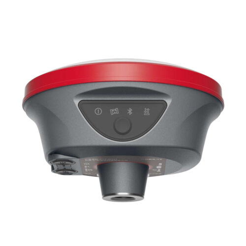

AR real-scene stakeout GNSS receiver L100 PRO+ for various surveying projects
L100 PRO+is a new generation of compact smart GNSS receivers designed for various surveying projects using latest GNSS features. This receiver equipped with modern required technologies such as Bluetooth module, IMU tilt sensor, 7000mAh lithium-ion internal battery, etc. L100 PRO+ is able to work in different work modes (Network RTK, Static & PPK) based on different required accuracy & conditions. L100 PRO+ is the most economic GNSS package you can purchase to fulfill your technical needs on field! -

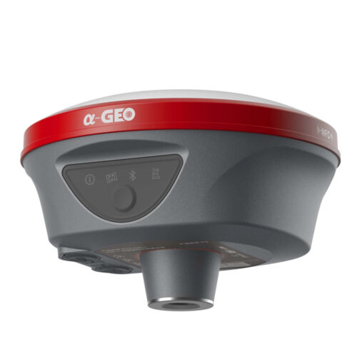
 L300 is a compact new generation of smart GNSS receiver designed for any surveying project using the latest GNSS technology.This receiver is equipped with all modern required connectivity modules: Bluetooth, Internal radio,WIFI & 4G modem. 6800mAh Built-in battery, IMU tilt technology and WebUl are other latest technologies used in L300 receivers. Download File
 -

 Matrix II Lite is a new generation of compact smart GNSS receivers designed for various surveying projects using latest GNSS features. This receiver equipped with modern required technologies such as Bluetooth module, IMU tilt sensor, 7000mAh lithium-ion internal battery, etc. Matrix II Lite is able to work in different work modes (Network RTK, Static & PPK) based on different required accuracy & conditions. Matrix II Lite is the most economic GNSS package you can purchase to fulfill your technical needs on field! Download File
 -


Functional GNSS Matrix III receiver merges Long-range laser+AR
Functional GNSS Matrix III receiver merges Long-range laser+AR -

 NetBOX2 is a brand new GNSS device with 1408 channels. It is small, but it is equipped with all required connectivity modules. Download File
 -

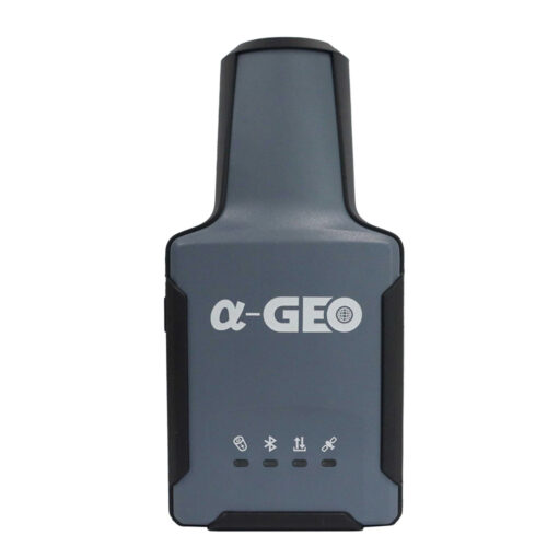
Smallest handheld laser RTK L2 Plus for most measurement scenarios.
As the saying goes, a sparrow may be small, but it has all the vital organs, same as to the L2 Plus of Alpha GEO, itis the smallest handheld RTK that integrates laser along with high-precision GNSS board and lMU in the compact body, offering a portable solution for most measurement scenarios. -

 Matrix Ultra integrates a high-efficiency 2W radio module to achieve the engineering optimal balance between power consumption and communication range. By dynamically adjusting transmit power, signal quality, and energy consumption, it delivers the best energy-performance efficiency (EPE) across various operational scenarios. Download File
 -

 The Matrix III Pro is a professional surveying and mapping device integrating laser measurement and AR launched by ALPHAGEO. Boasting a core breakthrough of 100-meter long-range laser measurement, it combines high-precision positioning, intelligent multi-module collaboration, strong environmental adaptability and efficient, practical design, and fully meets the demands of complex field surveying and mapping work. Download File